


La Grave lac de puy vachier

Roger Philippe Wallez
User GUIDE
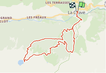

Length
12.8 km

Max alt
2401 m

Uphill gradient
1037 m
Km-Effort
27 km

Min alt
1443 m

Downhill gradient
1033 m
Boucle
Yes
Creation date :
2023-07-20 07:20:37.0
Updated on :
2023-07-20 13:55:24.406
6h33
Difficulty : Very difficult

FREE GPS app for hiking
 SityTrail
IGN / Geographical institutes
SityTrail Plus
The world is yours!
About
Trail Walking of 12.8 km to be discovered at Provence-Alpes-Côte d'Azur, Hautes-Alpes, La Grave. This trail is proposed by Roger Philippe Wallez.
Photos


Positioning
Country:
France
Region :
Provence-Alpes-Côte d'Azur
Department/Province :
Hautes-Alpes
Municipality :
La Grave
Location:
Unknown
Start:(Dec)
Start:(UTM)
287954 ; 4991577 (32T) N.
Comments